November 27, 2013

Credits: NASA/JPL/University of Arizona - Credits for the additional process. and color.: Dr Paolo C. Fienga/LXTT/IPF
|
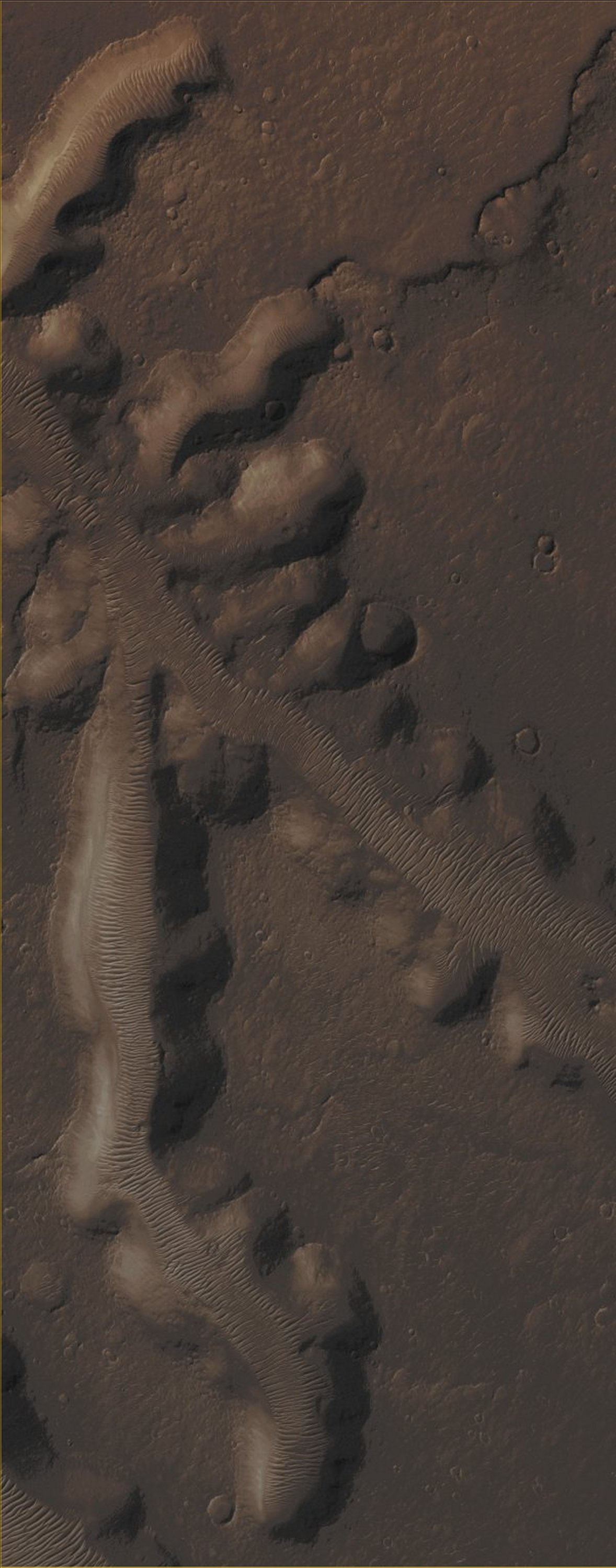
Nirgal Vallis (which is approximately 400 Km - such as 248,4 miles - long) is one of the largest and longest Valley Networks that can be found on the Planet Mars. Oriented roughly East-to-West and located to the North of the Giant Argyre Impact Basin, its Western Portion contains a great number of short and theater-headed Tributaries that merge into a long, sinuous, and deeply entrenched Main Valley which extends Eastward towards Uzboi Vallis. The area that is visible in this image shows us the Northern Portion of one of the Westernmost of the (aforementioned) Tributaries. The Valley's "Heads" are steep and abrupt with blunt terminations. Although Nirgall Vallis formed a very long time ago - likely by flowing Water and NOT Lava -, we can assume that abundant Wind-blown (---> Wind-carried) Sediments tuirned into the Dunefields that now line almost the entire Valley Floors. However, the distinctive Valley's pattern shape, with steep Walls and flat Floors, led many Planetary Scientists to suggest that huge (in fact, we should assumne enormous) amounts of ground-water flowed out to the Surface along the Valley's Heads and Walls of the numerous Tributaries. This process, known as "Sapping", usually begins with ground-water - flowing along some Subsurface Fractures (or Permeable Rocky Layers) and carrying Sediments with it - that, at a certain point, emerges (---> surfaces) at/very close to the Cliff's Face. Eventually, the loss of support from beneath, undermined the Cliff's Face, thus causing it to slump (---> slowly fall) into the Valley. With a continuous Sapping Process, the Tributaries grew progressively in a headward direction. This very specific kind of erosion is common in the Colorado Plateau of the Southwestern United States, and helped to form the distinctive shape of the Grand Canyon. Wrinkle Ridges intersecting several Tributaries may also have provided some additional avenues (---> ways/routes) for the ground-water to flow (even violently) into the Valley System. Mars Local Time: 14:44 (Early Afternoon) This picture (which is a crop taken from the NASA - Original Mars Reconnaissance Orbiter b/w and NON-Map Projected frame identified by the serial n. ESP_033814_1525) has been additionally processed, contrast enhanced, magnified, so to help the visibility of the smaller details, Gamma corrected, and then colorized in Absolute Natural Colors (such as the colors that a human eye would actually perceive if someone were onboard the NASA - Mars Reconnaissance Orbiter and then looked down, towards the Surface of Mars), by using an original technique created - and, in time, dramatically improved - by the Lunar Explorer Italia Team. |
News visualized: 776 times