April 23, 2013

Credits: NASA/JPL/University of Arizona - Credits for the additional process. and color.: Dr Paolo C. Fienga/Lunar Explorer Italia/IPF
|
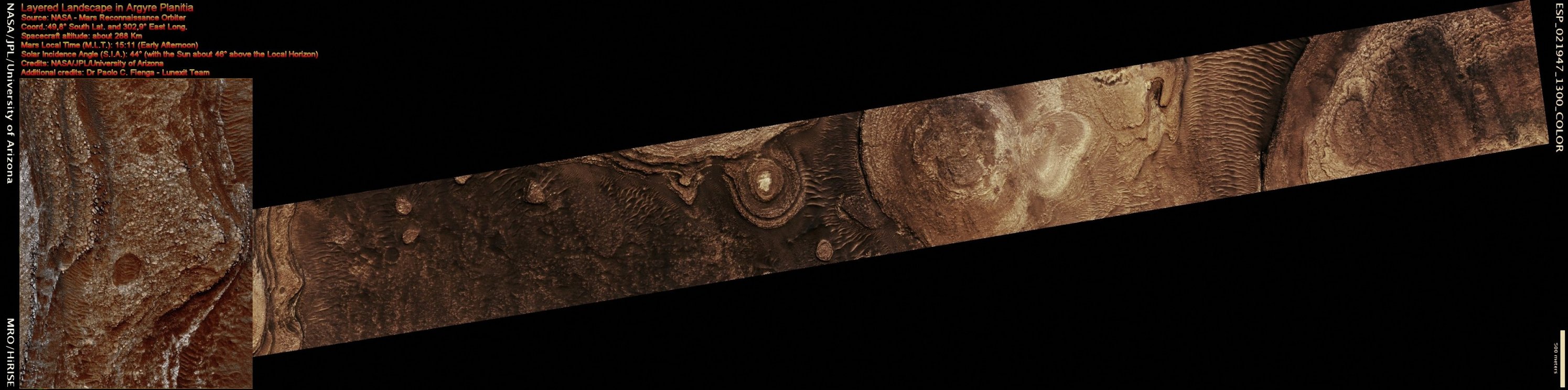
This observation, carried out by the NASA - Mars Reconnaissance Orbiter in the early April of the AD 2011, shows great exposures of Layered Rocks located in the Martian Region known as Argyre Planitia. Could these Surface Features be the evidence for the presence, in this Region and a very, very long time ago (perhaps a billion of years or so), of an ancient Sea or Lake? Only Time will tell... Argyre Planitia is a Plain approx. 1800 Km - such as about 1117,8 miles - wide and it is located in the Southern Highlands of Mars; its name comes from a map produced by Giovanni Schiaparelli in 1877 (where the Astronomer refers to the Island of Argyre: a mythical Island that was completely made of Silver, according to Greek Mythology). This Region is also the home of the huge Argyre Impact Basin, which contains some ancient and extremely eroded (---> highly deteriorated) Terrains, as well as other old Impact Craters that HiRISE has imaged in the past (like, for instance, Green Crater, Galle Crater, and the Charitum Montes. The EDM (which is approximately 1,2 Km - such as about 0,7452 miles - across) shows some of the Rocks and Layers with a greater and really impressive detail. Mars Local Time: 15:11 (Early Afternoon) These pictures (which are a NASA - Original Mars Reconnaissance Orbiter Map Projected CTX b/w frame identified by the serial n. ESP_021947_1300 and a NASA - Original Mars Reconnaissance Orbiter EDM false-color frame identified by the serial n. ESP_021947_1300-1) have been additionally processed and then colorized (and re-colorized, respectively) in Absolute Natural Colors (such as the colors that a human eye would actually perceive if someone were onboard the NASA - Mars Reconnaissance Orbiter and then looked down, towards the Surface of Mars), by using an original technique created - and, in time, dramatically improved - by the Lunar Explorer Italia Team. |
News visualized: 845 times