May 2, 2012

Credits: NASA/Magellan Probe Mission - Credits for the additional process. and color.: Dr Paolo C. Fienga/Lunar Explorer Italia/IPF
|
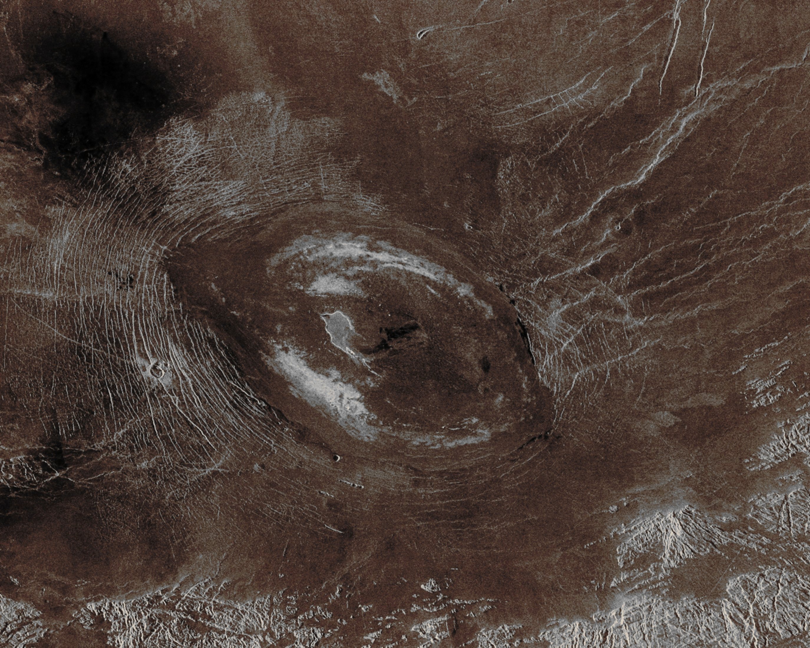
Sacajawea Patera is a very large and clearly elongated Volcanic Caldera located in the Western portion of the Venusian Region known as Ishtar Terra, on the smooth Plateau of Lakshmi Planum. This frame (which is a so-called "Radio-image") is centered at about 64,5° North Latitude and approx. 337° East Longitude, and it is approximately 420 Km (about 260 miles) wide at its base. Sacajawea is a depression approximately 1 to 2 Km (about 0,6 to 1,2 miles) deep and approx. 120 x 215 Km (such as about 74 x 133 miles) in diameter and, as we said before, clearly elongated in a South/West-North/East direction. The depression is bounded by a zone of Circumferential Curvilinear Structures which have been interpreted to be Graben and Fault Scarps. These structures are positioned of about 0,5 to 4 Km (0,3 to 2,5 miles) from one another and they are about 0,6 to 4 Km (such as approx. 0,4 to 2,5 miles) in width and up to about 100 Km (approx. 62 miles) in length. Extending up to approximately 140 Km in length from the South/East of the Patera, there is a System of Linear Structures that is thought to represent a Flanking Rift Zone along which the lateral injection and eruption of Magma may have occurred. A "Shield Edifice" about 12 Km (approx. 7,5 miles) in diameter, with a prominent Central Pit, lies along the trend of one of these Features. The Impact Crater Zlata, approximately 6 Km (such as about 3,7 miles) in diameter, is located within the zone of Graben to the North/West of the Patera. A few Flow Features can also be observed in association with Sacajawea, and they are possibly due to age and state of degradation of the flows. Mottled Bright Deposits of about 4 to 20 Km (such as from 2,5 up to 12 miles) in width are located near the periphery and in the center of the Patera Floor, within Local Topographic Lows. Diffuse Patches of A still unidentified Dark Material, approximately 40 Km (such as about 25 miles) in width, are observed to the South/West of the Patera, partially superposed on portions of the surrounding Graben. The formation of Sacajawea is thought to be related to the Drainage and Collapse of a large Magma Chamber. Furthermore, some Gravitational Relaxation may have also caused the resultant Caldera to sag, thus producing the numerous Faults and Graben that circumscribe it. Regions of complex, highly deformed Tessera-like Terrain are located North and East of the Patera, and they can be seen in the upper portion of the image. This frame, since it is just a Radio-Image of the Venusian Surface and NOT a real view of it, has been colorized in what they could reasonably be its possible Absolute Natural Colors (such as the colors that a human eye would perceive if someone were onboard the NASA - Magellan Probe and, once the thick layer of Venusian clouds shall have been completely overcome, looked down, towards the Surface of Venus), by using an original technique created - and, in time, dramatically improved - by the Lunar Explorer Italia Team.
|
News visualized: 807 times