April 26, 2012

Credits: NASA/Johns Hopkins University Applied Physics Laboratory/Carnegie Institution of Washington and Dr Paolo C. Fienga/LXTT/IPF for the additional process. and color.
|
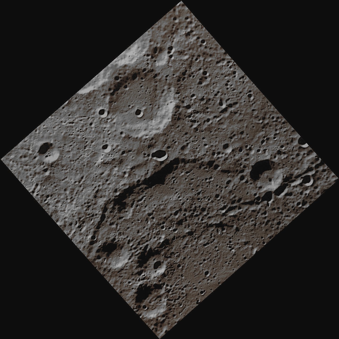
The Rim of the Double-Ring Basin Cervantes cuts through the middle of this NAC image. Cervantes Crater has a diameter of about 213 Km and was named in honor of the Spanish novelist, playwright, and poet Miguel de Cervantes (1547-1616), best known for his novel Don Quixote. The Craters that we can see all over the Planet Mercury range, in diameter, from small bowl-shaped cavities to multi-ringed impact basins, which are hundreds of kilometers across. They appear in all states of degradation, such as from (relatively speaking) Fresh Rayed Craters to highly Degraded Crater Remnants. As a matter of fact, the Mercurian Craters differ subtly from the Lunar ones, and the difference is in the fact that their surrounding areas, all blanketed by Ejecta, on Mercury, are much smaller than the ones of the Moon which, instead, are way wider. And why is that? Because, as you should know, the Planet Mercury possesses a much stronger Surface Gravity than our Moon does! The largest known Impact Crater on Mercury is called Caloris Basin, and it has a diameter of approx. 1550 Km. The impact that created the Caloris Basin was so powerful that it also caused some huge lava eruptions and left a Concentric Ring over 2 Km tall that surrounds the place where the main blast occurred. At the antipode of the Caloris Basin is a large Region of unusual, hilly terrain known as the "Weird Terrain". One hypothesis for its origin is that the Shock Waves generated during the Caloris impact traveled around the Planet, converging at the Basin’s Antipode (such as 180° away from the impact location) and the high stresses which resulted from the event, were strong enough to fracture large areas of the Mercurian Surface. Alternatively, it has been also suggested that this Terrain could have formed as a result of the Convergence of Ejecta at the Basin’s Antipode (but this theory, which is rather difficult to substantiate, in our opinion - as IPF - is not the one to be preferred). So far, about 15 Impact Basins have been already identified on the imaged portion of Mercury, and another notable Mercurian Basin is the 400 Km wide, Multi-Ring Tolstoj Basin, which has an Ejecta Blanket extending up to 500 Km from its Rim and a Floor that has been almost completely filled by Smooth Plains Materials. The Beethoven Basin, instead, has a similar-sized Ejecta Blanket and an about 625 Km diameter Rim. Most important to remember, is the circumstance that, like the Moon, also the Surface of Mercury has incurred the effects of the so-called Space Weathering Processes, such as, among others, the continuous influence of both Solar and Cosmic Wind, as well as an extremely long and heavy "Rain" of Micrometeorites (a "Rocky Rain" that, even though in a much smaller measure, we believe that is still going on). This image was acquired as part of MDIS's High-Resolution Surface Morphology Base Map. The Surface Morphology Base Map will cover more than 90% of Mercury's Surface with an average resolution of 250 meters/pixel (0,16 miles/pixel or 820 feet/pixel). Images acquired for the Surface Morphology Base Map typically have off-vertical Sun Angles (i.e.: high Solar Incidence Angles) and visible shadows so as to reveal clearly the topographic form of geologic features. On March 17, 2011 (March 18, 2011, UTC), MESSENGER became the first Spacecraft ever to orbit the planet Mercury. The mission is currently in its commissioning phase, during which the Spacecraft as well as the onboard instrument performance are verified through a series of specially designed checkout activities. In the course of the one-year primary mission, the Spacecraft's 7 (seven) scientific instruments and radio science investigation will try to unravel the history and evolution of the Solar System's Innermost Planet. This frame has been colorized in Absolute Natural Colors (such as the colors that a human eye would actually perceive if someone were onboard the NASA - MESSENGER Spacecraft and then looked down, towards the Surface of Mercury), by using an original technique created - and, in time, dramatically improved - by the Lunar Explorer Italia Team.
|
News visualized: 862 times